Hi,
tommorow I am writing test on geography, it will be on pedosphere, hydrosphere and atmosphere and since I forgot to learn atmosphere I decided that I will make post about winds and how air circulates on Earth so I can remember it.
The most important thing is that air wants to go from area of high pressure to area with low pressure, this is practicly the key thing in weather forecast because wind also takes rainfall with it and it is key when forming storms.
So it is important to know where are those areas of high and low pressure.
Low pressure areas create when there is warm air which expands thus lowering the pressure and then it rises. This of course happens on equator so there is low pressure always moving just a little bit north and south during year as the angle towards Sun changes.
On poles on the other side is high pressure because cold air falls down and its density increases because it is heavy.
Whole process is not so simple there is no gradient between equator and poles because there are lot other things that change this.

Key picture of winds on Earth
The picture above shows how air travels on Earth, I will start with the area of equator. So there is low pressure because of hot air. It raises and as anti trade wind (in Czech we call it anti-pasát) it goes north or south because the air is pushed by the new air coming. At about 40° the air loses all its humidity and temperature so it goes down. Because it is so dry at those areas deserts tend to create. This is area of high pressure compared to equator so the air goes south as trade wind. It is called like this because it helped sailors when they wanted to trade something. Around equator those winds are weaker and weaker and the air goes up because it is warmer. This area is called doldrums. It is famous for leaving boats powered by wind for weeks on same place, sometimes even killing whole crews since they can not move without wind.
This process described above is called Hadley cell.
Same thing happens around poles except the high pressure area is around poles so winds blow from there. This for example creates what is called tornado valley which is area in USA where hot air from south and cold air from Canada meet to create winds moving spiraly on small area: tornadoes.
It gets much more complicated on what is called Ferrel’s cell which is area between Hadley and Polar cell. Here lot of difference is also made by area above oceans and above land.
Because of Coriolis effect (Earth rotating), trade winds are turned towards west because of their inertia, Earth rotates from west to east.
Dragallur
Check out those two video for coriolis effect and how water turns in toilet:

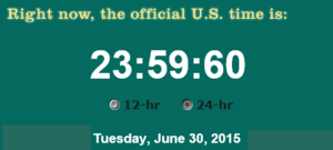 strange thing there. Unless you have some kind of strange clock you should not see 60 seconds normally but you should see instead one more minute and 00 seconds.
 30, 2015. This makes some problems in computing because of course all-time running programs with lot of data are not very well prepared to just add one second. This is also why those seconds are always allowed to be inserted two times per year.
 hemisphere. It is one of the most bright stars and and also Polaris is exactly at the point around which whole sky is rotating so it will always be on the same spot as you can see on the picture with high exposure.
 between two numbers should be 30°. If you are PRO then you will have sextant of course :D. You should measure 90° on poles and zero on equator.

